
Llanes coast · Llanes
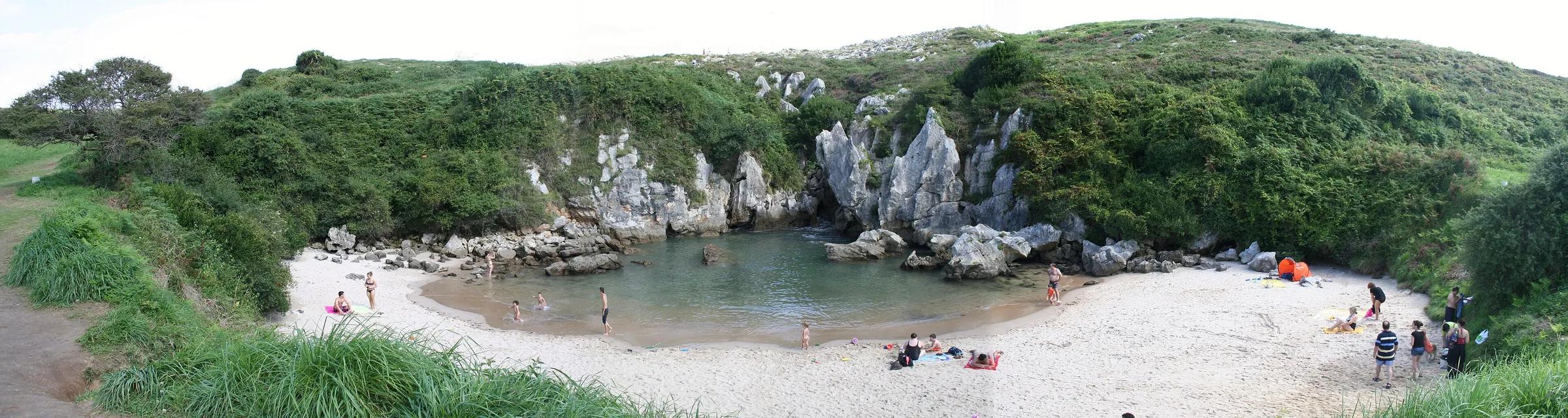
Playa de Gulpiyuri
A beach in a meadow, reached by the sea from underground
Franciaio / Wikimedia Commons, CC BY-SA 3.0
Gulpiyuri sits about 100 m from the open sea in a sinkhole among fields. Seawater enters through channels in the limestone, so the beach fills at high tide. It is a protected Natural Monument.
Why go
- One of the most unusual beaches in Europe.
Travel, stay and experience
Getting around, where to stay and what to experience around Playa de Gulpiyuri, from the guide's own records.
Getting around
- Aeropuerto Seve Ballesteros-Santander (SDR) · 86 km in a straight line
- Estación de Llanes · 11 km in a straight line
Where to stay
64 registered places to stay within 10 km (straight line). Nearest:
- Hotel La Fonte · 1 km in a straight line
- Hotel Villa Marrón · 1 km in a straight line
- Albergue Casa Rural Punta Pestana · 1 km in a straight line
Mapped by volunteers on OpenStreetMap; nothing is booked here.
Things to experience
Straight-line distances, not travel times. Tierra Luma shows no availability or prices and takes no bookings.
What to do here
Beaches
Time it with the tide
Visit around high tide to see water in the basin; at low tide it can be almost dry.
Leave room for discovery
Ideas, not instructions: take what suits your day.
- Food and a break
- For lunch, Llanes is about 11 km away in a straight line: wander its streets and see what tempts you. Or bring a picnic and stay outdoors.
- If you have time
- Follow the coastal path a little further than you meant to.
- Let the children choose which way to go next.
Things to do nearby
Activities whose place lies within 25 km in a straight line (not a road distance).
- Activity · 2 km awayBungee jumping by San Antolín beachViaduct beside San Antolín beach, near Naves, Llanes.
- Surfing · 2 km awaySurfing at San Antolín beach, LlanesSan Antolín beach, near Naves, Llanes (eastern coast).
- Kayaking · 11 km awaySea kayaking at Llanes and the Villaviciosa estuaryThe coast of Llanes and Ribadesella, and the Ría de Villaviciosa.
- Stand-up paddle · 11 km awayCave paddling on the Ribadesella–Llanes coastThe eastern Asturian coast between Ribadesella and Llanes, especially around Llanes.
- Family · 11 km awayTreetop adventure park in LlanesCamino de la Colmenera, La Pereda (Llanes).
- Gravel cycling · 14 km awayGravel ride from Ribadesella to VillaviciosaRibadesella/Ribeseya to Villaviciosa, eastern-central Asturian coast.
About this place
Protected as: Monumento Natural, part of the Red Regional de Espacios Naturales Protegidos of Asturias.
Landscape and rock
Gulpiyuri is a flooded sinkhole set into a karst platform, cut off from the open sea by about 100 metres of land. The sea still reaches it, through a cavern beneath the rock, so the little beach feels the tides and even the push of the waves; at spring high tides it fills like a saltwater pool. The beach itself is tiny, around 40 metres long and some 15 metres wide on average, with sand and calm water, and it is ringed by green meadows. It lies north of the village of Naves, between Punta Rociera and Castro Molina.
How to get there
Transport and visitor services nearby
- Estación de LlanesTrain station · 11 km
- Oficina de turismo de LlanesTourist office · 11 km
- Estación de RibadesellaTrain station · 14 km
- Oficina de turismo de RibadesellaTourist office · 14 km
- Oficina de turismo de OnísTourist office · 14 km
- Oficina de turismo de CabralesTourist office · 17 km
Straight-line distances, never travel times.
Plan your visit
- Near the village of Naves; parking is limited.
Accessibility
Reached by a short footpath across fields; not step-free.
Visit with care
Gulpiyuri can only be reached on foot: the tracks from San Antolín beach and from the village of Naves are closed to vehicles, so leave the car behind and walk the last stretch. There are no toilets, showers or other services, so bring what you need and carry every scrap of litter out again. The beach is surrounded by farmland, so keep to the track, close any gates and leave livestock in peace. Because the water only arrives with the tide, check the tide tables if you want to see it full. This is a protected Natural Monument: leave sand, stones and plants where they are.
Local services nearby
- Canoas OrienteAdventure operator · 15 km
- Cangas AventuraAdventure operator · 22 km
- Los Cauces AventuraAdventure operator · 24 km
- Jaire AventuraAdventure operator · 25 km
- Frontera VerdeAdventure operator · 25 km
Straight-line distances, never travel times.
Safety
- Protected site: do not remove sand or stones.
In the journal
Getting here & services nearby
The nearest published airport, stations and visitor centres, in a straight line from this place. Check routes and timetables with the operator.
- Aeropuerto Seve Ballesteros-Santander (SDR)Airport · 86 kmView details
- Estación de LlanesTrain station · 11 kmView details
- Estación de RibadesellaTrain station · 14 kmView details
- Estación de autobuses de Cangas de OnísBus station · 22 kmView details
- Oficina de turismo de LlanesTourist office · 11 kmView details
- Oficina de turismo de RibadesellaTourist office · 14 kmView details
- Oficina de turismo de OnísTourist office · 14 kmView details
- Canoas OrienteAdventure operator · 15 kmView details
Nearby
Within 30 km in a straight line. Distances are not travel times: valleys and mountain roads decide those.
More places nearby
- Playa La Huelga y Playa de la CanalinaBeach · Asturias · 1 kmExplore place
- Playa de San AntonioBeach · Asturias · 2 kmExplore place
- Playa de PestañaBeach · Asturias · 2 kmExplore place
- Cuetu de la MinaCave · Asturias · 3 kmExplore place
- Cueva de la CoberizaCave · Asturias · 3 kmExplore place
- Playas de Sovalle, Valle y NiembroBeach · Asturias · 4 kmExplore place